
Neighbouring Countries of India 2024 (India map geographical map)
Neighbouring Countries of India 2024 (India map geographical map) – India is based in the southern part of the Asia and Asian oceans. It’s 2nd largest country in the Southeast Asian countries. It’s located in the Northern hemisphere and eastern hemisphere of the whole world.
India holds’s world’s highest population in the whole world and is also the seventh largest country in the world as per area. India has a very largest geographical area with a 15,106.7 KM land border and a very long coastline of 7,515.6 km.
In this article, you can read which countries share their border with India and its states. Here we mention all the important information about neighbouring countries which helps to share and increase general knowledge to understand the agreement with the geography of India-related questions and answers.
All Neighbouring Countries of India 2024 – Overview
India has a total land frontier of 15,106.7km. And total coastline length of India is 7,516.6 km. India has 7 Neabour countries that abound its international border line. These 7 countries are ‘AFGHANISTAN, PAKISTAN, CHINA, BHUTAN, NEPAL, MYANMAR, BANGLADESH, MALDIVES AND SRILANKA‘.
Neighbouring Countries of India 2024 |
India Neighboring Countries |
|---|---|
| Total Count of Neighbouring Countries of India (India map geographical map) | 9 |
| All Indian Neighbouring Countries’ name | AFGHANISTAN, PAKISTAN, CHINA, BHUTAN, NEPAL, MYANMAR, BANGLADESH, MALDIVES AND SRILANKA |
| India shares Total Land Border with neighbouring countries’ name | 15,106.7 k.m. |
| Totle Indian Coastline Length | 7516.6 km |
| Covers | Static Gk of Neighboring Countries |
| Exams Covered on this topic | All competitive exams |
| Article Source | Government of India Website and his data |
Read More – Budget 2024 Live Updates – Budget 2024-25 की मुख्य बातें
India’s all neighbouring countries‘ names, capitals, total borders and states
Indian share his boundaries with |
Country
|
Capital |
Bordering States |
Border Length |
India shares boundaries with Afghanistan is |
Afghanistan |
Kabul |
Ladakh (PoK) |
106 Km |
India shares boundaries with Bangladesh is |
Bangladesh |
Dhaka |
West Bengal, Meghalaya, Mizoram, Tripura and Assam |
4096.7 Km |
India shares boundaries with Bhutan is |
Bhutan |
Thimphu |
West Bengal, Sikkim, Arunachal Pradesh & Assam |
699 Km |
India shares boundaries with China is |
China |
Beijing |
Ladakh, Himachal Pradesh, Uttarakhand, Sikkim and Arunachal Pradesh |
3488 Km |
India shares boundaries with Myanmar is |
Myanmar |
Naypyidaw, Yangon |
Arunachal Pradesh, Nagaland, Mizoram and Manipur |
1643 Km |
India shares boundaries with Nepal is |
Nepal |
Kathmandu |
Bihar, Uttarakhand, UP, Sikkim and West Bengal |
1751 Km |
India shares boundaries with Pakistan is |
Pakistan |
Islamabad |
Jammu and Kashmir, Ladakh, Punjab, Rajasthan and Gujarat |
3323 Km |
India shares boundaries with Sri Lanka is |
Sri Lanka |
Colombo (Commercial), Sri Jayawardenepura Kotte (Legislative) |
It is separated from India by the Gulf of Mannar |
Sea Border |
India shares boundaries with Maldives is |
Maldives |
Male |
It is attached to Indian south-west part of the Indian Ocean below Lakshadweep Island |
Sea Border |
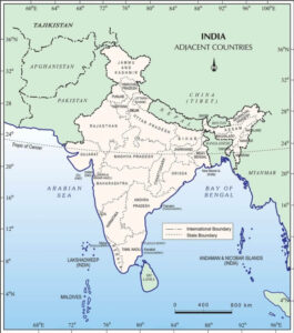
India map geographical map of Neighbouring Countries 2024 –
Here you can see the latest geo map of India which shares the boundaries with Neighbouring Countries of India (India map geographical map)